
Central Asia is one of the most tectonically active regions of the world and is influenced by two major climate systems: The west wind zone and the monsoon. CaTeNA is examining the two most serious natural hazards arising from these conditions: Earthquakes and mass movements. The goal is to better understand the underlying processes and triggering factors and to better estimate the resulting risks.
Natural Hazards in Central Asia
The mountain regions of Central Asia are exceptionally threatened by natural hazards, in particular earthquakes and mass movements. As population, infrastructure and wealth grow in Central Asia, their vulnerability to natural hazards also increases. While the risk associated with earthquakes is readily apparent, the threat of mass movement events is often underestimated. In fact, in Central Asia, and especially in the Tian Shan and Pamir regions, strong earthquakes in the past have often been accompanied by destructive landslides which claimed a large number of casualties.
Risk and vulnerability assessments
Risk and vulnerability assessments are therefore a key task in preparing Central Asian states and societies for such extreme recurrent events. However, these also require a deeper understanding of the processes underlying natural hazards as well as deeper insights into their timescales, rates and interconnections. In order to clarify such correlations, in addition to the observable changes (e.g. of the climate or the tectonic activity), long-term process sequences which go beyond the time scales of instrumental recordings as well as their dimensions and causes must be investigated.
Central Asia lacks widely available data and tools to better understand the causes of natural disasters and their associated risks to the population. The CaTeNA joint project addresses this deficit. It aims to generate new insights, data as well as products and services and to provide them to authorities, non-governmental organisations, educational and research institutions or other interested parties.
A building in Kyrgyzstan destroyed by the magnitude 6.8 Nura earthquake. © German Research Center for Geosciences, Dr. Bernd Schurr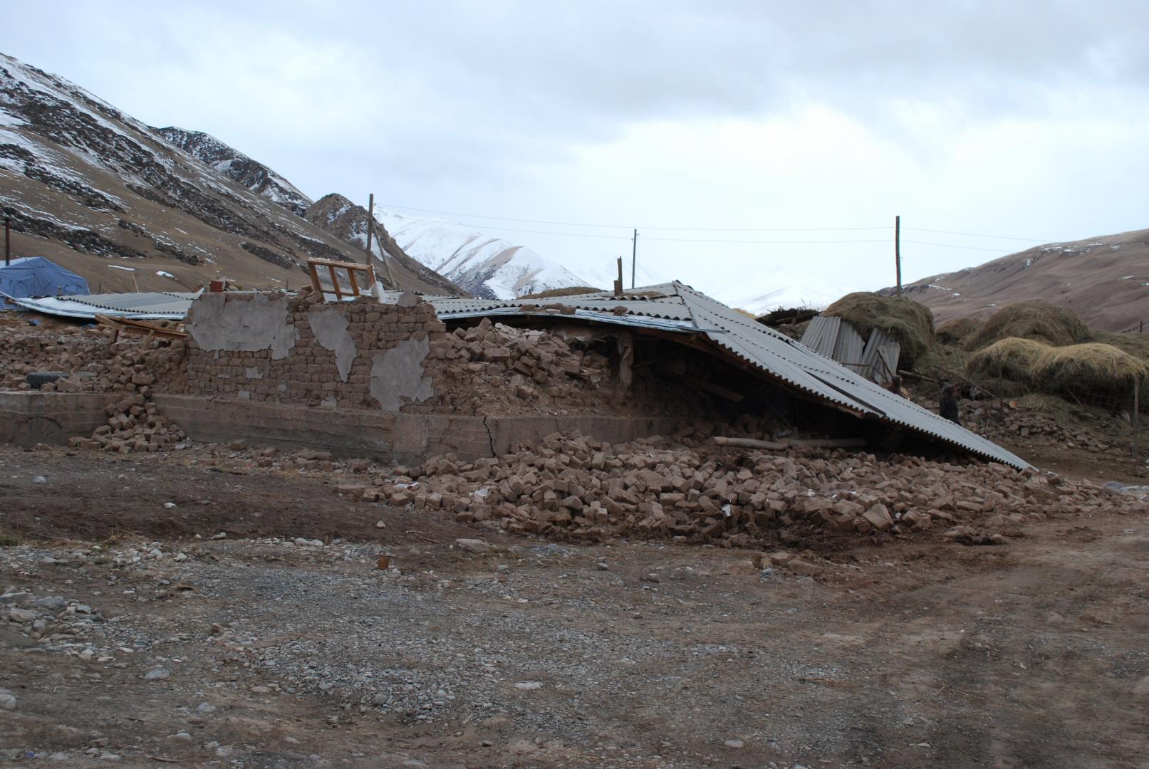
A central prerequisite for the assessment of natural risks such as earthquakes and mass movements in mountain regions is knowledge of the local tectonic conditions. For this purpose, CaTeNA localises tectonic distortions and determines deformation rates and their changes. The localisation of deformation to disturbances and its association with the occurrence of mass movement in the most tectonically active zone of Central Asia, the deformation belts of the Pamir and Tian Shan mountains, over the last 10 million years to date will be determined and described by the project. The two most active disturbances, the Main Pamir Thrust and the Darvaz Fault, should determine the offset rates of the opposing tectonic plate segments and the recurrence intervals of large earthquakes as well as allow for better understanding of their relationship to mass movements. The current deformation field is to be characterised and quantified using the methods of space geodesy and seismology. CaTeNA, in addition to earlier and parallel studies, is focusing on the north and northeast of the Pamirs, where three major high magnitude earthquakes occurred during the last year. The results will be incorporated into the openly accessible Central Asian Tectonic Database developed within the project, making it accessible to the public, stakeholders and decision-makers. They form the basis for a more accurate estimation of the risk for earthquakes and landslides.
Temporary seismic station in the Pamir Mountains. © German Research Center for Geosciences, Dr. Bernd Schurr
Long-term goal: Early warning
Another important project goal is the development and implementation of a dynamic risk assessment for landslides, including current seismic soil motion maps and high-resolution, model-based precipitation and snowmelt maps. This allows for an improved estimation of the effects of geological hazards on inhabited areas and traffic infrastructure, for example. Direct and efficient risk communication should be achieved through interactive visualisation based on a dynamic multilingual web GIS platform. This is an essential step on the path to an early-warning system that takes into account the most important triggering factors.